
Analysis of the cosmogenic nuclide beryllium -10 produced in bedrock and river sediment samples has contributed to an understanding of how the vertical sandstone pillars of Zhangjiajie China have evolved through time and when they were formed.
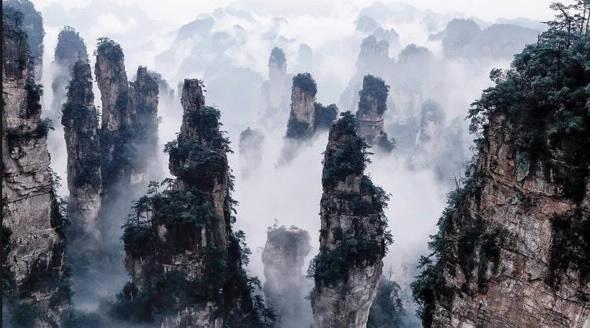
There are more than 3000 sandstone peaks and pillars up to 350 metres tall in Zhangjiajie UNESCO Global Geopark in Hunan China.
The research was carried by a group of Chinese and international scientists who used a combination of techniques to decipher the complex geological processes that led to the evolution of the striking landscape.
Both the composition of sandstone, as well as weathering and erosion processes, were known to contribute to the formation of the geological characteristics of the ‘peak forest’ but untangling the interactions was challenging.
“They had no idea if the pillars were very young like hundreds of thousands of years or if they were very old—even perhaps up to a few million years ,” said David Fink, an expert in the use of cosmogenic nuclides applied to landscape evolution and a Principal Research Scientist at the Centre for Accelerator Science and in Environment at ANSTO
Measuring the concentration of beryllium-10, a cosmogenic nuclide formed when cosmic rays bombard rocks on the surface of Earth, in bedrock and river sediment helped to establish the timescales over which the sandstone pillars have evolved, and the rates of weathering they have experienced.
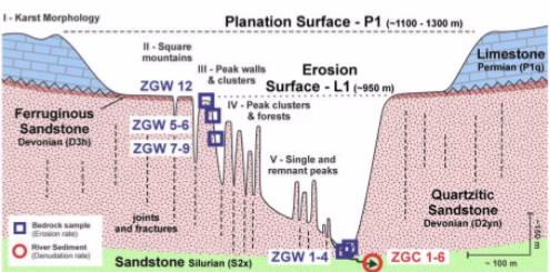
The area under investigation was once capped by very strong iron sandstone, which had weathered to expose porous quartz sandstone. Once this capping was removed, river channels began in earnest to remove the more vulnerable underlying sandstone.
"With time deep river incision created a network of narrow and steep gorges that today is called a sandstone forest. But when did all this start and how long has it taken to create this surreal landscape?
We were able to measure beryllium-10 in bedrock from the top of the sandstone pillars to work out how much of it was being lowered by weathering and then we also measured beryllium-10 concentrations in river sediment to determine how much the river was incising the sandstone from below.
Basically we were using beryllium-10 as a monitor of sediment removal and subsequent transport into the rivers. The longer the surfaces are maintained the higher the concentrations and vice versa,” explained Fink.
“Hence, we can determine if the surfaces are young or old depending on their inventory of cosmogenic nuclides accumulation with time,“ he said.
“Because the Chinese team under Jing Gu and Jan Hendrik May of the University of Freiburg also arranged for local residents to collect samples from the sheer vertical walls (some hundreds of meters tall), it was also possible to determine the a third component of the system – how quickly were the vertical walls retreating— their horizontal erosion rates.”
Fink pointed out that it was because all the erosion rates were different that changes to the landscape occurred.
“The maximum erosion rate at the tops of the stone pillars was around 100 times slower than the incision rates by the rivers. The samples from the vertical walls had varying rates.“
‘The rivers were cutting away sandstone faster than the pillar tops were lowering in a process known as extended relief, ” said Fink.
The group of investigators concluded that the formation of the vertical sandstone pillars, was relatively recent, between 100,000 and 200,000 years ago. The research was recently published in the reputable journal Earth Surface Processes and Landforms and featured on the front cover of the journal volume. .
Collaborating organisations included University of Freiburg (Germany), University of Melbourne, Institute of Geographic Sciences and Natural Resources Research (China), ANSTO, University of Wollongong and the Institute of Remote Sensing and Digital Earth (China)
Drs David Fink and Toshiyuki Fujioka, who are co-authors on the paper, measured the beryllium-10 concentrations in a range of bedrock, rock wall and river sediment samples using Accelerator Mass Spectrometry on the ANTARES accelerator and analysed the results to determine bedrock erosion rates and times of exposure.
Alexandru ‘Tibi” Codilean at the University of Wollongong used a digital elevation map of the Zhangjiajie UNESCO Global Geopark with a geographical information system to convert the river sediment 10Be data to enable calculation of the average river channel incision rates.
The combination of the two analyses provided a complete picture of the landscape evolutionary processes and timing of the Zhangjiajie pillars. The approach can be applied to understand the formation of other sandstone formations around the globe.
The Zhangjiajie pillars were the inspiration for the floating formations in the science fiction film Avatar.
https://onlinelibrary.wiley.com/doi/epdf/10.1002/esp.4273