
The use of bomb-pulse radiocarbon has become widespread as a precise dating tool for the last 60 years, leading to new applications in forensic science, biology, physiology, plant and animal growth, and climate studies.
Carbon-14 (14C) was generated by nuclear explosions in the atmosphere due to weapons testing, mostly in the 1950s and 1960s, and the resultant 14CO2 gradually being distributed throughout Earth’s atmosphere and essentially put a mark in time and can be used as an accurate dating technique.
The atmospheric 14CO2 level is now approaching its natural prebomb value. In the troposphere – the region of Earth’s atmosphere below about 10,000 metres – the level of bomb-derived 14CO2 was extremely variable in space and time.
For this reason, if we want to radiocarbon-date materials formed during the last 60 years, we need to know what those atmospheric levels were – both when and where. Fortunately tree rings, studied in this research, have recorded this information as the trees have hotosynthesised the 14CO2 into cellulose in their annual rings.
In this study, researchers from ANSTO and Naresuan University measured the level of radiocarbon in tree rings from Thailand, Indonesia and Australia, using ANSTO’s particle accelerators. The results, together with published radiocarbon data from tree rings and atmospheric carbon dioxide samples from around the world, revealed that the level of atmospheric 14CO2 during the early bomb period from the mid-1950s to the late 1960s was strongly influenced by world-wide atmospheric circulation patterns.
Using this compilation, we have been able to reconstruct regional and temporal records of atmospheric 14CO2 levels to make carbon dating a more accurate chronological tool.
Natural and bomb-derived 14C
Radiocarbon or 14C is continuously formed in the atmosphere by interactions of the cosmic-ray secondary neutron flux with atmospheric 14N. This is a purely natural process. Following its production, 14C is oxidised to form atmospheric 14CO2, (or atmospheric 14C in short), which is then transferred to the oceans through air-sea gas exchange and enters living organisms (e.g., plants and animals) via photosynthesis, food-chain and metabolic processes.
|
|
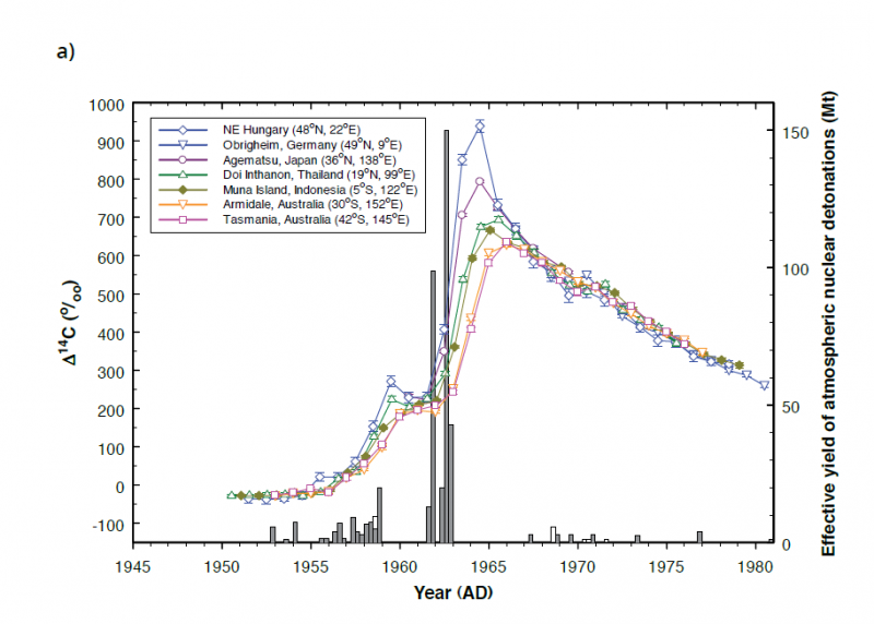
| Figure 1a: Tree-ring 14C at different latitudes and the magnitude of atmospheric nuclear detonation. Grey and white bars represent total effective yield of atmospheric nuclear detonations for 3-month periods for the Northern and Southern Hemisphere, respectively. |
Consequently, the 14C content of living organisms is in equilibrium with that of the atmosphere. Once the 14C uptake ceases (e.g., at the death of an animal or when wood cellulose is formed), the 14C content of the organism starts to decrease at a rate determined by its half-life of 5730 years. This is the basis for traditional radiocarbon dating for samples older than 1950, which in favourable cases can be as precise as ±20 calendar years.
A large amount of 14C was artificially produced between 1945 and 1980 when hundreds of nuclear weapons were detonated in the atmosphere (Fig. 1a). Nuclear bomb blasts produced intense fluxes of thermal neutrons, which in turn reacted with atmospheric 14N to form 14C. As a result, the concentration of 14C in the atmosphere increased dramatically in the late 1950s and early 1960s, and peaked in the mid-1960s at nearly double the pre-bomb level.
Significantly different atmospheric 14C levels between consecutive years during the period from 1955 onwards offer the possibility of dating recent terrestrial materials by 14C with a resolution that can be as good as a single year. Such applications require a detailed knowledge of the radiocarbon bomb-pulse.
|
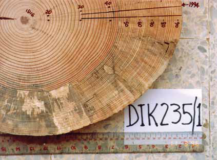
| Figure 1b: Cross-section of Thai three-leaf pine tree DIK 235/1 with rings from 1916 to 1994, from which a sub-section was used for AMS 14C analysis. |
New tree-ring 14C data
We have measured 14C in tree rings from the tropics and southern midlatitudes where atmospheric 14C data are scarce. It is worth noting that tree-ring 14C is a direct representation of atmospheric 14C values during the growing season of tree rings [1]. The tree rings used in our study included three-leaf pine (Pinus kesiya) from Doi Inthanon, Thailand (Fig. 1b), teak (Tectona grandis) from Muna Island, Indonesia, Pinus radiata from Armidale, Australia, and Huon pine (Lagarostrobos franklinii) from Tasmania, Australia.
Four sets of single tree rings from the early 1950s to the mid-1970s were pre-treated to alpha-cellulose then converted to graphite for Accelerator Mass Spectrometry (AMS) 14C analysis using ANTARES and STAR accelerators at ANSTO [2].
Our results together with published data for the northern hemisphere (NH) are shown in Fig. 1a. The levels of the tree-ring 14C bomb peaks decrease from north to south indicating a fast transport of bomb 14C within 0.5-1 year from the northern temperate regions to the tropics and a further 0.5-1 year to the southern temperate regions.
|
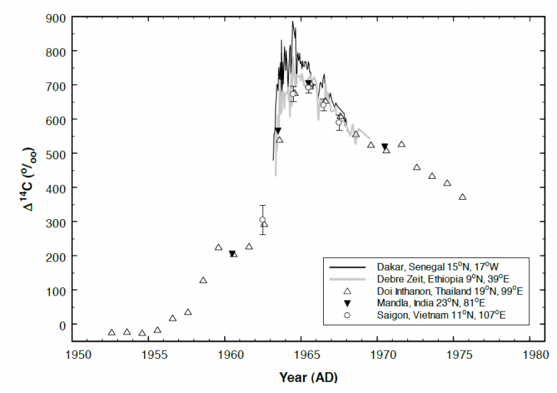
| Figure 2: Radiocarbon in tree rings versus atmospheric 14C at similar latitudes for the northern tropics. Lines represent atmospheric 14C data. Symbols depict tree-ring 14C values. |
Influence of atmospheric circulation on regional 14C
As most of the atmospheric nuclear tests were conducted in the northern hemisphere (Fig. 1a), there were large, transient 14C disequilibria in the troposphere (north versus south and high-latitudes versus low-latitudes) during the early bomb period from the mid-1950s to the late 1960s. This significantly increased the 14C-contrast between regional air masses.
Figure 2 shows our Thailand data in comparison with published 14C data at similar, northern-tropical latitudes in tree rings at Mandla (India) and Saigon (Vietnam), and in atmospheric CO2 samples from Debre Zeit (Ethiopia) and Dakar (Senegal). The tree-ring data match each other very well. They also match very well with 14C data for Debre Zeit, but all of them exhibit much lower 14C values than the atmospheric data for Dakar.
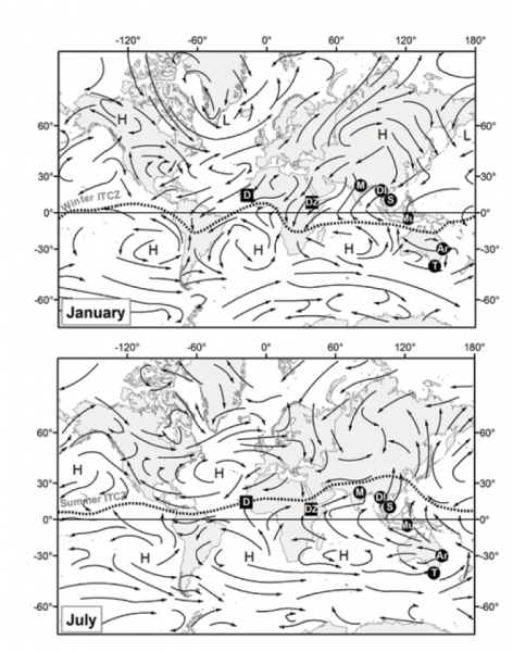
The significant difference between Dakar 14C values, and those from Debre Zeit, Mandla, Saigon and Doi Inthanon can be attributed to the summer African/Asian monsoon, and the position of the Inter-Tropical Convergence Zone (ITCZ) during the summer time relative to the locations of these sites [3]. During the growing season of northern hemisphere tree rings (May-August), Dakar and the latter sites are on different sides of the ITCZ (Fig. 3). Dakar is located north of the summer ITCZ and receives air masses from northern mid-latitudes.
Meanwhile, the latter sites are located south of the summer ITCZ and influenced by southern hemisphere (SH) air (carried by the summer African/Asian monsoon) with a 14C level significantly lower than that for the northern mid-latitudes during the early bomb period.
The 14C levels of Muna Island in the southern tropics are significantly higher than those derived from mid-latitude southern hemisphere 14C records (e.g., Armidale and Tasmania) for the periods of rapidly rising atmospheric 14C (Fig. 1a). During the growing season of southern hemisphere tree rings (November–February), Muna is located well north of the winter ITCZ (Fig. 3) and strongly influenced by northern hemisphere air masses carried by the winter Asian monsoon [4].
Meanwhile Armidale and Tasmania remain covered by southern hemisphere air masses containing much less 14C than those from the northern hemisphere during the early bomb period.
Meanwhile Armidale and Tasmania remain covered by southern hemisphere air masses containing much less 14C than those from the northern hemisphere during the early bomb period.
|
| Figure 3: Mean positions of the Inter-Tropical Convergence Zone (ITCZ) for January and July and global atmospheric circulation together with locations of atmospheric stations (squares) and tree ring sites (circles). H is a typical centre of high atmospheric pressure, and L is a centre of low atmospheric pressure.
Atmospheric stations indicated are D, Dakar and DZ, Debre Zeit. Tree ring sites indicated are Ar, Armidale; DI, Doi Inthanon; M, Mandla; Mu, Muna Island; S, Saigon and T, Tasmania.
|
Zonal atmospheric 14C data for dating
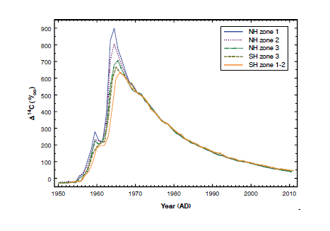
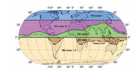
The spatial distribution of bomb radiocarbon during the early bomb period did not have a simple latitudinal radient but consisted of various, more-or-less uniform zones separated by atmospheric circulation cell boundaries and the ITCZ positions [3-5]. Based on this, we have reconstructed five zonal 14C levels namely NH zones 1, 2 and 3, and SH zones 3 and 1-2 [5] (see Fig. 4 a and b).
The highest atmospheric 14C level during this period was in NH zone 1, where most of the excess 14C was injected into the troposphere. The level of atmospheric 14C decreased from north to south as the excess 14C was transferred southwards by atmospheric circulation. The spatial distribution of bomb 14C in the southern hemisphere would probably consist of three zones similar to those for the northern hemisphere.
However, the excess 14C became diffused after it was transported over the broad and seasonally moving ITCZ resulting in an almost uniform 14C level for the region south of the winter ITCZ (SH zone 1-2).
In summary, our results have significantly improved our knowledge of the influence of atmospheric circulation on regional 14C differences, which is very important for accurate radiocarbon dating. In addition, five zonal 14C data sets have been reconstructed to be used as “radiocarbon calibration curves” for improved bomb-pulse 14C dating in order to facilitate a fast growing demand in the application of bomb radiocarbon in various research disciplines including forensic studies, biomedical research and soil carbon dynamics.
|
| Figure 4a: Regional tropospheric 14C curves for the period 1950-2010 for five different zones. |
|
| Figure 4b: The five zones into which the tropospheric 14C levels have been reconstructed. |
Quan Hua1, Mike Barbetti2, Vlad Levchenko1, Andrew Smith1
1 ANSTO, 2Naresuan University, Thailand
Acknowledgements
We would like to thank Stuart Hankin for the preparation of Figures 3 & 4.
References
- Cain, W.F., & Suess, H.E. (1976). Carbon-14 in tree rings. Journal of Geophysical Research, 81(21), 3688-3694.
- Fink, D., Hotchkis, M., Hua, Q. et al. (2004). The ANTARES AMS Facility at ANSTO. Nuclear Instruments and Methods in Physics Research B, 223-224, 109-115.
- Hua, Q., & Barbetti, M. (2007). Influence of atmospheric circulation on regional 14CO2 differences. Journal of Geophysical Research, 112, D19102.
- Hua, Q, Barbetti, M., Levchenko, V.A., D’Arrigo, R.D., Buckley, B.M., & Smith, A.M. (2012). Monsoonal influence on Southern Hemisphere 14CO2. Geophysical Research Letters, 39, L19806.
- Hua, Q., Barbetti, M., & Rakowski, A.Z. (2013). Atmospheric radiocarbon for the period 1950-2010. Radiocarbon, 55, 2059-2072.