
|
|
| Photo Credit: PermaCultured |
On average, there is now 17 per cent less rainfall across Western Australia’s south-western region than was recorded prior to 1970. This rainfall reduction has economic, social and environmental implications for the region, in particular for the growing capital of Perth, as well as water-dependent industries in the state.
Only short term rainfall records (110 years or so) are available to work with, so scientists researching the cause of this rainfall decrease need to apply different climate research methods to get a longer term understanding of rainfall patterns to assist with predicting the rainfall patterns. Interestingly, it is cave stalagmites that are helping to provide the answers.
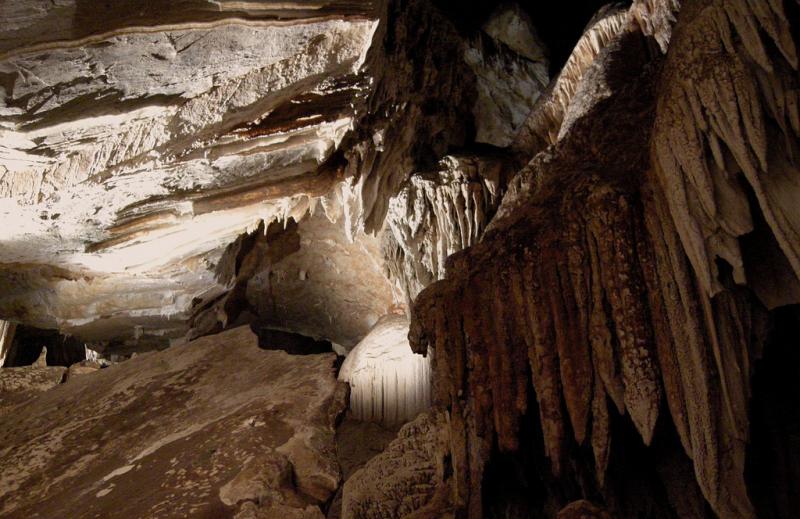
Cave stalagmites are a rock formation that rises from the floor of a cave due to the accumulation of material deposited on the floor from minerals dissolved in dripping water. These structures form slowly over thousands of years and with nuclear techniques, scientists are able to use the stalagmites to help unlock thousands of years of rainfall-sensitive data, preserved in the crystallised calcium carbonate.
The first step in this process is to assess whether one of potentially hundreds of individual stalagmites in a cave is suitable for generating past climate records and that’s where ANSTO comes in. Working in Western Australia, Pauline Treble and her colleagues monitored drip water and studied how sensitive and accurate individual stalagmites are as indicators of rainfall and climate change.
In fact, using nuclear techniques and their expertise, ANSTO researchers have recently produced one of the longest cave monitoring datasets in Australia, from Golgotha Cave in south-west Western Australia. The data has confirmed the cave’s suitability for gathering stalagmite-based rainfall records.
South-west Western Australia climate change
Rainfall is now on average 17 per cent less across the south-west Western Australia region compared with earlier data prior to 1970 [1]. Due to the consequent reduction in surface water availability has had large economic, social and environmental impacts in this region, which includes Western Australia’s capital Perth, due to economically important water-dependent industries and population growth pressure.
Much effort has been directed to understand the cause of this decline. But it remains difficult to assess the role of natural variability from the current short-duration meteorological record (110 years or so) because of the multi-decadal nature of the dry period. Hence, there is an urgent need to extend baseline information on natural climate variability for this region. Reconstructing past-climates using climate-sensitive ‘proxies’ in cave stalagmites has emerged as an effective way to achieve this [2].
|
|
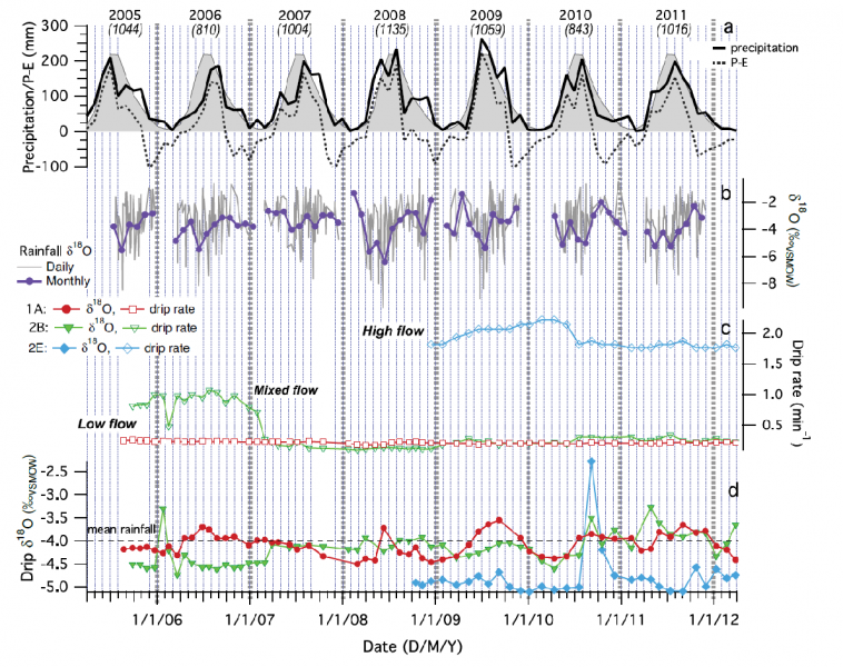
Precipitation and precipitation minus evapotranspiration (P-E) (a); rainfall oxygen isotopic composition or δ18O (b); and cave observations of drip rate (c) and drip δ18O (d) at three sites in the cave high-flow drips (blue diamonds) display distinctly lower drip δ18O owing to selective recharge of a secondary reservoir by high-magnitude rainfall events. Not all data from all sites are shown. See [3] for full report.
|
‘Climate’ records from caves
We have demonstrated previously that climate-sensitive ‘proxies’ of rainfall which become preserved in growing stalagmites may be used to track climate change in south-western WA stalagmites [2]. This was achieved by measuring the geochemical record in a modern stalagmite from this region which had grown on a tourist boardwalk between 1911 and 1992 [2].
We cut open the stalagmite and measured trends in the oxygen isotopic ratio (18O/16O or δ18O) along the stalagmite growth axis using mass spectrometry. We were able to verify that the speleothem recorded the post- 1970 dry period because of the change in the 18O/16O ratio due to fewer intense storm events, which typically carry more 18O-depleted moisture, during the dry period [2].
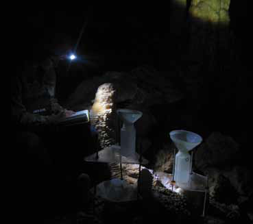
The extension of the south-west WA paleoclimate record is currently underway, however, a critical part of this study required a long-term monitoring program to attempt to capture the drying signal in the caves via measurements of the dripwater. Drip points were carefully studied for over six years. The cave was fitted out with data loggers and water collection devices, and Department of Environment and/or ANSTO staff visited the caves each month to collect the data.
Our findings
In summary, our six-year-long cave study (see Fig. 1), has led to a number of findings that have important implications for our ultimate goal of reconstructing paleoclimate records from south-west WA stalagmites.
We found that our monitored cave is particularly suitable as: 1) the dripwater preserved the oxygen isotope (δ18O) from the rainfall; 2) the cave had a high infiltration rate (typically <1 year from recharge); and 3) negligible isotopic impact of evapotranspiration [3], i.e. the sum of evaporation and plant transpiration from the land surface to atmosphere. Our study also captured some of the driest years on record in the region and this ‘dry’ signal was detectable in the dripwater.
Consequently, we can reconstruct the long-term rainfall records from the stalagmites in this cave.
|
|
|
Pauline Treble making measurements in Golgotha Cave, south-west Western Australia. Photo: Andy Baker. |
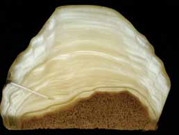
Cross-section of a 2,000 year old stalagmite from Golgotha Cave. (Height of stalagmite is approximately 10m.) Photo: Pauline Treble. |
Implications for paleoclimate records
Our study also reinforced the importance of investing in long term cave monitoring projects when constructing stalagmite paleoclimate records as we found that not all of our sites captured the rainfall signal in the same way. A key uncertainty in this research is how the hydrological pathways in the cave ceiling may interfere with the transfer of the rainfall signal, e.g. by way of mixing, storage, attenuation and bypass flow [4,5].
This process is poorly understood. Our findings showed that low-flow drip sites, typical of much of the cave, are recharged by an even distribution of rainfall events evidenced by the agreement between mean dripwater and rainfall δ18O; and by the (attenuated) seasonal δ18O cycles similar to that observed in rainfall (Fig. 1). In contrast, our high-flow sites are sustained by a secondary reservoir recharged by isotopically distinct high magnitude rainfall events.
Stalagmite records from our low-flow sites are thus most likely to reflect mean conditions and be the most straightforward to interpret. However, records from high-flow sites with their bias to high-magnitude events will provide a useful comparison to detect multi-decadal (or longer) shifts in the intensity of storms, such as that observed in the meteorological record since the 1970s.
Next steps
Our long intensive study of the cave environment has paved the way to a better understanding of the climate records preserved in Golgotha Cave stalagmites. The stalagmites from the studied drips have now been removed and the construction of the records, extending as far back as8,000 years, is now in progress. These records will provide long datasets of natural variability in the south-west WA climate that are critically needed for testing climate models and leading to improved water resource and land management planning.
Acknowledgements
The authors would like to thank the Department of Environment and Conservation, WA for allowing access to cave sites and supporting the fieldwork. Thank you to Ian Fairchild, Warren Bond, Paul Rustomji, and Andy Spate for assistance with fieldwork and to Cath Jex, Michael Gagan, Monika Markowska, Carol Tadros and Joan Cowley for assistance with lab analyses.
Pauline C. Treble1, Chris Bradley2, Anne Wood3, Andy Baker4
1ANSTO, 2University of Birmingham, United Kingdom, 3Department of Environment and Conservation, Western Australia, 4University of New South Wales, New South Wales
References
- Hope, P., Timbal, B., & Fawcett, R. Associations between rainfall variability in the south-west and south-east of Australia and their evolution through time. (2010). International Journal of Climatology, 30(9), 1360-1371.
- Treble, P. C., Chappell, J., Gagan, M. K.,McKeegan, K. D., & Harrison, T. M. (2005). In situ measurement of seasonal delta O-18 variations and analysis of isotopic trends in a modem speleothem from south-west Australia. Earth And Planetary Science Letters, 233(1-2), 17-32.
- Treble, P. C., Bradley, C., Wood, A., Baker, A., Jex, C. N., Fairchild, I. J., et al. (2013). An isotopic and modelling study of flow paths and storage in Quaternary aeolinite, SW Australia: implications for speleothem paleoclimate records. Quaternary Science Reviews, 64, 90-103.
- Bradley, C., Baker, A., Jex, C. N., & Leng, M. J. (2010). Hydrological uncertainties in the modelling of cave drip-water d18O and the implications for stalagmite palaeoclimate recontructions. Quaternary Science Reviews, 29(17-18), 2201-2214.
- Fairchild, I. J., & Baker, A. (2012). Speleothem Science: From process to past environments. Oxford: Wiley-Blackwell.