
ANSTO environmental scientists are using nuclear techniques to determine the extent of soil erosion on a NSW vineyard.
|
|
| With soil samples, scientists can determine the extent of erosion and have an indication if erosion control measures have been effective. |
“This is just one example of how environmental science can assist Australian industries,” said ANSTO Environmental Scientist, Henk Heijnis.
The research is also part of the International Atomic Energy Agency (IAEA) Regional Cooperative Agreement Project on Improving Soil Fertility, Land Productivity and Land Degradation Mitigation (RAS-5055). All 15 participating international countries including Australia have identified a ‘hot spot’ as a national project.
“We assess the soil erosion projects undertaken by other countries but this is an opportunity to do our own,” said Heijnis. Australia will report on the project at an international meeting later in the year.
Soil erosion by water has been occurring at an unsustainable rate. “It is a significant problem in huge areas of land in Australia,” said Heijnis.
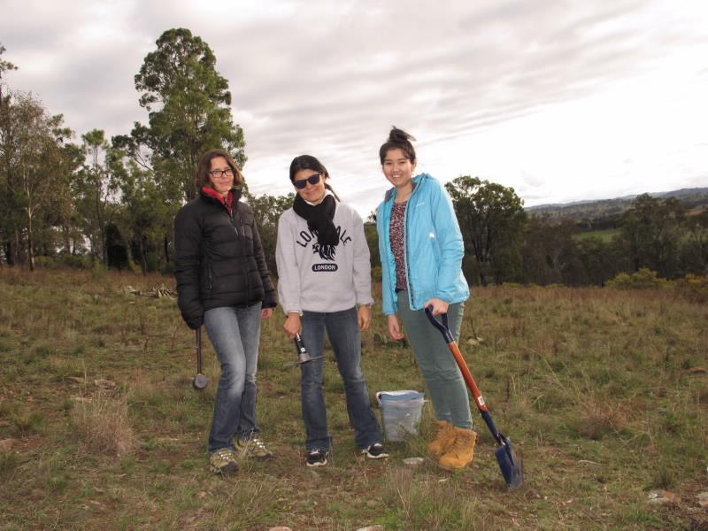
ANSTO graduate Yvonne Armstrong will be working on the project under the supervision of Heijnis, who is also Australia’s representative on the IAEA international project group.
Soil erosion can limit the productivity of vineyards. Sloped areas of vineyards are naturally prone to erosion with water run-off.
Heijnis connected with David Lowe, the Chief Winemaker of the Lowe Winery, who has been actively trying to do a better job in managing the vineyard and improving the condition of the soil.
“He is also interested in science, which helps,” said Heijnis, who spent a day and a half at the Mudgee winery with a small team.
“He is also interested in science, which helps,” said Heijnis, who spent a day and a half at the Mudgee winery with a small team.
Prior to the establishment of vines in 1995, the land had been a typical Australian property used for crops and sheep farming. Now the property is divided between vineyards and a farm.
With natural slopes on the property, water erosion was a threat Lowe had already started trying to limit. Contour banks were constructed on the slopes to slow down the water flow and prevent the formation of channels and gullies. Lowe also erected fencing to keep cattle out of areas where there was natural vegetation that protects topsoil.
The first part of the field work involved soil sampling from two reference sites on the property, where the topsoil is relatively undisturbed by land use.
“There was an area where not much had happened except for a bit of grazing but no tilling or building work. The presence of large well established trees confirmed the suitability of the location,” explained Heijnis.
“There was an area where not much had happened except for a bit of grazing but no tilling or building work. The presence of large well established trees confirmed the suitability of the location,” explained Heijnis.
The top of another hill opposite the first site was selected for the second reference site. Collection involves taking soil samples, which are retrieved by tapping a short cylindrical tube into the topsoil.
With soil samples, scientists can determine the extent of erosion and have an indication if erosion control measures have been effective. They do this by using specific environmental tracers found in the soil: lead-210, beryllium-7 and caesium-137. These tracers will be measured by Yvonne and gamma spectrometry expert Daniela Fierro in the special low level gamma spectrometry facility of the Environmental Radioactivity Measurement Centre at ANSTO.
They should be present in the soil and they should decay with depth. If all the topsoil is gone, then all the traces of these elements will be somewhere else, possibly down the hill.
“We look for the extent of the isotope signal in the samples and compare everything that might have been lost or gained in the soil against the reference site.”
Depending on how much of the signature you find, you can determine the amount of sediment lost.
Soil erosion is very difficult to control in sloped areas because water gains speed as it moves downward.
“It is amazing what water can do. Even one big rainstorm can shift a metre or two of soil. The quicker it moves, the more displacement you get.”
“It is amazing what water can do. Even one big rainstorm can shift a metre or two of soil. The quicker it moves, the more displacement you get.”
There is another five or six days of field work on the property. After the analysis, we expect to tell the owner how much soil he is losing.
The team hopes to locate another vineyard with similar sloping that is not organic to use for comparison purposes.
They also have the option of ‘fingerprinting’ land use by sampling sediment from the dams on the property.
In 2001 the Australian Government’s State of the Environment Report showed that annual soil loss is commonly greater than one tonne per hectare across most of Australia. Accordingly, Australia’s Chief Scientist, Ian Chubb, alongside the Australian Research Council (ARC), have identified soil and water as two, of many, current strategic research priorities.